
Bihar Under Siege: Record-Breaking Floods Breach Gandak Embankments, Triggering Mass Evacuations
By Editorial Desk
October 2, 2026
The state of Bihar is currently grappling with a severe hydrological crisis as the Gandak River, swollen by unprecedented inflows, has breached critical embankments, submerging vast swathes of land across the Saran, Gopalganj, and Muzaffarpur districts. As of Thursday, October 1, 2026, the situation remains precarious, with government agencies working on a war footing to manage what officials are describing as a multi-river surge that defies the state’s current rainfall patterns.
Main Facts: The Scope of the Inundation
The catastrophic flooding has been precipitated by a series of structural failures in flood-control infrastructure. Following massive discharges from upstream—driven by extreme rainfall events in Nepal and neighboring Uttar Pradesh—the Gandak River has exerted immense pressure on embankments that were already strained.
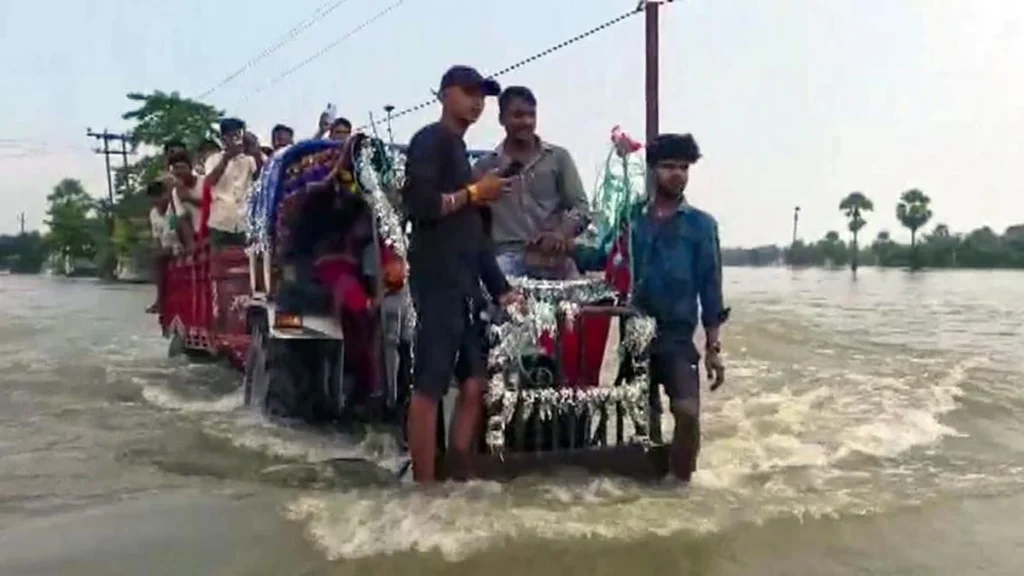
The most critical breaches occurred in the Shitalpur dam in Gopalganj, a rupture in the Panapur area of Chhapra (Saran), and a failure in the ring bund of the Tirhut main embankment in the Sahebganj block of Muzaffarpur. These breaches have allowed floodwaters to surge into residential villages, forcing thousands of residents to abandon their homes. In scenes reminiscent of the state’s most difficult flood years, families are being evacuated via tractors and emergency boats, clutching whatever belongings they can salvage.
The phenomenon is exacerbated by the "backflow" effect. With the Ganga River already flowing above its danger mark, the Gandak’s discharge is being slowed, causing water to pool and rise rapidly behind embankments. This hydraulic stalemate has created a secondary crisis, as the water has nowhere to go but out into the surrounding countryside.

Chronology of the Crisis: A 48-Hour Emergency
The timeline of the disaster highlights the rapid escalation of the threat:
- Pre-October 1: Initial concerns were raised as rainfall in the catchment areas of Nepal and Uttar Pradesh spiked. West and East Champaran were the first to report breaches, signaling that the flood wave was moving downstream with significant velocity.
- October 1 (Early Hours): The water level at Dumaria Ghat (Gopalganj) surpassed the Highest Flood Level (HFL) by 22 cm. This critical threshold remained breached for over 36 hours, placing unprecedented stress on the earthen embankments.
- October 1 (Mid-Day): The situation deteriorated at Rewaghat (Saran) and Lalganj (Vaishali), where water levels sustained a position above the HFL for 24 hours. Concurrently, the breach at the Shitalpur dam and the Tirhut ring bund occurred, leading to immediate inundation of several blocks.
- October 1 (Evening): The Bihar Water Resources Department identified "critical seepage and piping" at three specific locations along the Saran embankment. Emergency flood-fighting crews were deployed to reinforce these points with sandbags and heavy earthmoving equipment.
- October 2 (Early Morning): While officials report a slight decline in the Gandak’s water level, it remains historically high. The state has entered a "48-hour high-alert" window, during which the residual pressure on water-logged embankments is expected to be at its most volatile.
Supporting Data: An Anomalous Hydrological Event
What makes the 2026 flood particularly confounding to climate experts and state planners is the discrepancy between the rainfall and the river levels. Despite Bihar having recorded 32% less rainfall than the seasonal average, the river systems are experiencing record-breaking inflows.
This suggests that the disaster is driven entirely by trans-boundary water management and extreme weather events in the upper catchments of the Gandak and Sone rivers. The record water inflows in the Ganga, Gandak, and Sone concurrently represent a "triple threat" rarely seen in the state’s history.
The hydraulic pressure, currently exceeding all previous records, has pushed the limits of the existing flood-control infrastructure. Engineers note that even when river levels begin to recede, the "piping" (where water finds a subterranean path through an embankment) continues to pose a severe risk of sudden collapse, necessitating continuous 24-hour monitoring of vulnerable stretches.
Official Responses and Government Action
Chief Minister Samrat Choudhary has taken personal command of the monitoring efforts, conducting site inspections at the JP Ganga Path to assess the rising water levels of the Ganga. His administration has shifted into emergency mode, prioritizing the safety of the displaced population.

"The government is fully alert," Chief Minister Choudhary stated during his briefing. "We have sought assistance from the Indian Air Force to reach areas that are completely cut off by the rising waters."
The mobilization efforts include:
- Air Force Intervention: An Indian Air Force helicopter has been deployed to conduct aerial reconnaissance and airdrop dry rations to the stranded populations in the Panapur block of Saran, where ground access has been rendered impossible by the floodwaters.
- NDRF Deployment: 14 teams from the National Disaster Response Force (NDRF) are currently operating in the affected districts. Their mandate is twofold: conduct high-risk rescues of individuals trapped in rooftops or isolated hamlets, and ensure the orderly distribution of aid to relief camps.
- Infrastructure Vigilance: The Water Resources Department has mobilized flood-fighting teams on a "war footing." These crews are tasked with identifying and plugging seepage points before they turn into full-scale breaches.
The administration has instructed local district magistrates to ensure that relief centers are adequately stocked with food, clean water, and medical supplies.
Implications: The Long-Term Vulnerability of Bihar
The current crisis serves as a stark reminder of Bihar’s inherent vulnerability to its riverine geography. The breach of embankments—many of which were built decades ago—raises uncomfortable questions regarding the maintenance of flood-control assets in an era of climate volatility.
The Challenge of Embankment-Based Control
For years, the policy of "embanking" rivers has been debated by environmentalists. Critics argue that confining rivers like the Gandak leads to siltation, which raises the riverbed over time. Eventually, the riverbed sits higher than the surrounding land, turning any breach into a catastrophic event. The current situation, where the water is above the HFL despite lower-than-average local rainfall, supports the theory that upstream sediment load and extreme weather events are rendering traditional embankment strategies less effective.

Economic and Agricultural Impact
With the flood occurring in early October, the agricultural implications are severe. Standing crops in the affected districts are likely to be lost, which will have a cascading effect on the local economy. The displacement of rural laborers and the destruction of rural infrastructure—including roads and livestock shelters—will require a significant financial intervention from the state government for reconstruction and recovery.
The 48-Hour Outlook
The immediate focus remains the next 48 hours. As the water begins to slowly recede, the saturated soil of the embankments becomes highly susceptible to sliding. The administration’s decision to maintain "special vigilance" is not merely precautionary; it is a recognition that the most dangerous period for an embankment often occurs as the pressure begins to subside, potentially revealing structural weaknesses created during the peak flow.
Conclusion
The 2026 flood crisis in Bihar is a testament to the complex, trans-boundary nature of water security. As the state balances the immediate humanitarian imperative of rescuing those stranded with the technical necessity of preventing further structural breaches, the narrative remains one of resilience in the face of an unforgiving natural phenomenon.
For the people of Saran, Gopalganj, and Muzaffarpur, the next two days will be critical. The state’s ability to prevent further loss of life will depend heavily on the continued efficacy of the NDRF operations and the rapid repair of the breaches. As the water levels eventually retreat, the government will face the daunting task of assessing the damage and rethinking the long-term sustainability of the state’s flood-management architecture in an increasingly unpredictable climate.